12. ỨNG DỤNG ẢNH HỒNG NGOẠI NHIỆT LANDSAT - 8 TIRS NGHIÊN CỨU SỰ PHÂN BỐ NHIỆT ĐỘ BỀ MẶT HUYỆN LỘC BÌNH, TỈNH LẠNG SƠN
Thanh bên bài viết
-
Viễn thám Remote sensing
Giới thiệu
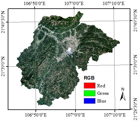
Bài báo giới thiệu cơ sở lý thuyết và thực nghiệm xác định nhiệt độ bề mặt đất từ ảnh hồng ngoại nhiệt LANDSAT - 8 TIRS khu vực huyện Lộc Bình, tỉnh Lạng Sơn năm 2017. Ảnh vệ tinh LANDSAT - 8 trước tiên được chuyển đổi giá trị số nguyên sang giá trị bức xạ điện từ, sau đó xác định nhiệt độ độ sáng. Dựa vào chỉ số thực vật chuẩn hóa (NDVI) để xác định độ phát xạ bề mặt sau đó tính toàn nhiệt độ bề mặt. Kết quả cho thấy: (i) Nhiệt độ thấp phân bố tại khu vực có đồi núi cao và có thảm thực vật che phủ dày đặc; (ii) Nhiệt độ cao tập trung ở khu vực nơi có mật độ dân cư dày đặc; (iii) Nhiệt độ rất cao và dị thường nhiệt xuất hiện tại khu vực khai thác than của mỏ than Na Dương. Ứng dụng ảnh hồng ngoại nhiệt LANDSAT - 8 TIRS giúp nghiên cứu sự phân bố không gian nhiệt độ bề mặt một cách hiệu quả và nhanh chóng.
Toàn văn bài báo
Trích dẫn
[2]. Trần Hùng (2007). Sử dụng tư liệu MODIS theo dõi độ ẩm đất/thực vật bề mặt: Thử nghiệm với chỉ số mức độ khô hạn nhiệt độ - thực vật (TVDI). Tạp chí Viễn thám và Địa tin học, Số 2, trang 38 - 45.
[3]. Trịnh Lê Hùng (2014). Ứng dụng dữ liệu viễn thám hồng ngoại nhiệt LANDSAT nghiên cứu độ ẩm đất trên cơ sở chỉ số khô hạn nhiệt độ - thực vật. Tạp chí Các khoa học về Trái đất, Tập 36, số 03, trang 262 - 270.
[4]. Trịnh Lê Hùng, Đào Khánh Hoài (2015). Ứng dụng viễn thám đánh giá nguy cơ hạn hán ở huyện Bắc Bình, tỉnh Bình Thuận. Tạp chí Khoa học Đại học Sư phạm thành phố Hồ Chí Minh, số 05(70), trang 128 - 139.
[5]. Trịnh Lê Hùng, Vũ Danh Tuyên, Vương Trọng Kha (2016). Phương pháp viễn thám trong đánh giá ảnh hưởng của quá trình khai thác khoáng sản đến tình trạng hạn hán khu vực mỏ sắt Thạch Khê, tỉnh Hà Tĩnh. Hội thảo Khoa học Kỹ thuật Mỏ toàn quốc lần thứ 25, trang 129 - 135.
[6]. Doãn Hà Phong (2007). Xây dựng thuật toán và phương trình xác định nhiệt độ bề mặt đất trong theo dõi cảnh báo cháy rừng trên cơ sở ảnh vệ tinh MODIS (TERRA và AQUA) trên lãnh thổ Việt Nam. Luận án Tiến sỹ, Trường Đại học Mỏ - Địa chất.
[7]. Trần Xuân Trường (2010). Xác định độ ẩm mặt đất bằng phương pháp viễn thám không gian. Luận án Tiến sỹ, Trường Đại học Mỏ - Địa chất.
[8]. Garcia Cueto O.R., Jauregui Ostos E., Toudert D., Tejeda Martinez A. (2007). Detection of the urban heat island in Mexicali and its relationship with land use. Atmosfera 20 (2), pp. 111 - 131.
[9]. Vlassova L., Fernando Perez-Cabello, Hector Nieto, Pilar Martin, David Riano, Juan de la Riva (2014). Assessment of methods for land surface temperature retrieval from LANDSAT 5 TM images applicable to multiscale tree-grass ecosystem modelling. Remote Sensing, 6, 4345 - 4368.
[10]. Vlassova Lidia, Fernando Perez - Cabello, Marcos Rodrigues Mimbrero, Raquel Montorio Lloveria, Alberto Garcia-Martin (2014). Analysis of the relationship between land surface temperature and wildfire severity in a series of Landsat images. Remote Sensing, 6, 6136 - 6162.
[11]. Valor E., Caselles V (1996). Mapping land surface emissivity from NDVI. Application to European African and South American areas. Remote sensing of Environment, 57, pp. 167 - 184.
[12]. Garcia Cueto O.R., Jauregui Ostos E., Toudert D., Tejeda Martinez A. (2007). Detection of the urban heat island in Mexicali and its relationship with land use. Atmosfera 20(2), pp. 111 - 131.
[13]. USGS (2015). Tài liệu hướng dẫn về xác định nhiệt độ bề mặt từ ảnh LANDSAT. Trang: https://landsat.usgs.gov/documents/.